The Sketch Plat, if submitted by the Sub-divider, shall have include the information described in this section.
1. The Sub-divider shall provide a report to City staff estimating the impact the Sketch Plat will have on city traffic flow, utility production and distribution, and all franchised utilities. The Rural Water District shall provide a report in the Planning Area.
2. The Sub-divider shall provide a report describing the following:
2.1. Narrative describing the project.
2.2. Project phasing and timing.
2.3. Proposed land use including type, size, and density along with activities to take place.
2.4. Adjacent and surrounding land uses.
3. The Sketch Plat shall be drawn to scale and contain the following:
3.1. Boundary lines.
3.2. Lots.
3.3. Existing streets, utility facilities, and major easements.
3.4. Motor vehicle, pedestrian, and other traffic and circulation.
3.5. Community facilities.
3.6. Natural environmental features such as habitat, wetlands, and natural hazards.
The Preliminary Plat and vicinity map shall be drawn to an appropriate scale approved by the Zoning Administrator. The engineer/surveyor preparing the plat shall provide one copy in the scale of one inch equals 100 feet.
1. Narrative. The following information shall be described in a project narrative report.
1.1. Narrative describing the project.
1.2. Project phasing and timing.
1.3. Proposed land use including type, size, and density along with activities to take place.
1.4. Adjacent and surrounding land uses.
1.5. Utilities.
1.6. Motor vehicle, bicycle, and pedestrian circulation and traffic.
1.7. Community facilities.
1.8. Natural environmental features such as habitat, wetlands, and natural hazards.
1.9. Market analysis, if deemed necessary by the Administrator.
2. General Information. The following general information shall be shown on the Preliminary Plat:
2.1. The proposed name of the subdivision.
2.2. Date of Preparation, north pointing arrow, and scale of drawing.
2.3. Identification as a Preliminary Plat.
2.4. Location of the subdivision by quarter-section, township and range and by measured distances to a section corner to further define the location and boundaries of the tract.
2.5. Names of adjacent subdivisions or, in the case of un-platted land, the name of the owner(s) of adjacent property.
2.6. The name and address of the owner, the sub-divider, and the surveyor who prepared the plat.
3. Existing Conditions. The following existing conditions shall be shown on the Preliminary Plat:
3.1. The location, width and names of all existing public or private streets within or adjacent to the tract, together with easements, rights-of-way, and other important features such as section lines and corners, city and township boundary lines and monuments.
3.2. The horizontal location and elevation within the subdivision and the horizontal location in the adjoining streets and property of existing sanitary sewer and storm water sewers including flow lines, water mains, culverts, underground wiring, pipe lines and gas lines proposed to serve the property to be subdivided.
4. Contour lines or spot elevations based on Mean Sea Level (MSL) or other datum approved by the Planning Commission having the contour intervals of two foot contours for ground slopes less than 10%, five foot intervals for ground slopes exceeding 10% and spot elevations where the ground is too flat for contours.
4.1. The date of the topographic survey(s) shall be shown including the location, elevation and description of the benchmark controlling the vertical survey and the location of existing monuments and survey markers.
5. The location and direction of all watercourses and area subject to flooding, including the floodway and flood fringes areas, where available.
6. Significant natural features such as rock outcroppings, marshes, lakes and wooded areas.
7. Existing use of the property including the location of all existing structures showing those that will be removed and those that will remain on the property after the Final Plat is recorded.
8. Boundary line of proposed subdivision clearly indicated and total acreage therein.
9. Streets, showing the location, width, names and approximate grades thereof. The Preliminary Plat shall show the relationship of all streets to any projected streets shown, or any applicable Comprehensive Plan proposal, or if none proposed, then as suggested by the Planning Commission.
10. Easements showing the width and purpose.
11. Lots showing approximate dimensions, minimum lot sizes and proposed lot and block numbers.
12. Location and type of utilities to be installed including provisions for storm water drainage including existing and proposed drainage easements and detention facilities.
13. Sites, if any, to be dedicated or reserved for park, playground or other public purposes.
14. Minimum front yard building setback lines as established by applicable zoning or other regulations, or more restrictive setbacks if desired by the sub-divider.
15. A vicinity map showing existing subdivisions, streets and un-subdivided tracts adjacent to the proposed subdivision and showing the manner in which the proposed streets may be extended to connect with existing streets.
16. The following information shall be submitted with the Preliminary Plat:
16.1. Preliminary Master Drainage Plan. (See Section 502 and Section 503 for Preliminary Master Drainage Plan requirements)
16.2. Preliminary Utility Plan.
16.3. A statement of the manner in which it is proposed to finance improvements including any improvements that are to be installed by petition.
The Preliminary Master Drainage Plan presented to the Planning Commission at the time the Planning Commission considers a Preliminary Plat must have the following:
1. Existing ground contours shall be shown at the same interval as required for Preliminary Plats. Benchmark information shall be included.
2. Existing spot elevations shall be shown at top of curbs on connecting streets, inlets, storm sewers and other physical sections that will govern the runoff from the proposed subdivision.
3. Areas where the proposed subdivision will accept drainage from outside the perimeter of the proposed subdivision.
4. Locations of discharges from the proposed subdivision and characteristic of the receiving system (ditches, storm sewer, etc.)
5. Proposed top of curb elevations at control points such as intersections and vertical point of intersections.
6. Proposed percent grade of streets.
7. Preliminary locations and sizes of storm sewers and channels.
8. Arrows and labels showing proposed direction of lot drainage, cross-lot drainage and locations of drainage swales.
9. Proposed location of drainage easements.
10. Proposed type of foundation/basement system for each lot.
In the Planning Area, a drainage plan shall be presented to the Planning Commission at the time the Planning Commission considers the Preliminary Plat that includes the following:
1. Existing ground contours shall be shown at the same interval as required for Preliminary Plats. Benchmark information shall be included.
2. Areas where the proposed subdivision will accept drainage from outside the perimeter of the proposed subdivision.
3. Locations of discharges from the proposed subdivision and characteristic of the receiving system (ditches, storm water, etc.).
4. Proposed percent grade of ditches.
5. Preliminary locations and sizes of storm sewers, ditches and channels.
6. Arrows and labels showing proposed direction of lot drainage, cross-lot drainage and locations of drainage swales.
7. Proposed location of drainage easements.
8. For lots less than 1 acre and/or subdivisions with planned water features, the following additional information may be required:
8.1. Type of foundation (i.e. view-out basement; walk-out basement; slab floor; pad elevation; etc.).
8.2. Lowest structure opening.
8.3. Water feature 100-year flood elevations.
The Final Plat shall be prepared by a Kansas Licensed Surveyor, and drawn in waterproof black ink on tracing cloth, Mylar or their equivalent. Alternatively, a Final Plat may be prepared by a photographic process provided it is submitted on 0.004 inch polyester photographic film such as Mylar or its equivalent. The permitted page size shall be 24 inches by 36 inches, or a size acceptable for recording. Larger sizes will not be accepted. The scale shall be 100 feet to one inch except that a variation in scale may be allowed where the Zoning Administrator determines it is necessary for proper exhibit of the subdivision. When more than one sheet is used for any plat, each sheet shall be numbered in relation to the total number of sheets. Linear dimensions shall be given in feet and decimals of a foot. (Ordinance No. 1697)
1. Narrative. The following information shall be described in a project narrative report.
1.1. Narrative describing the project.
1.2. Project phasing and timing.
1.3. Proposed land use including type, size, and density along with activities to take place.
1.4. Adjacent and surrounding land uses.
1.5. Utilities.
1.6. Motor vehicle, bicycle, and pedestrian circulation and traffic.
1.7. Community facilities.
1.8. Natural environmental features such as habitat, wetlands, and natural hazards.
1.9. Market analysis, if deemed necessary by the Administrator.
1.10. Any other relevant factors for the development proposal as deemed appropriate and necessary by the Administrator.
The Final Plat shall show on the face thereof:
2. The name of the Subdivision, its legal description with reference to its location by quarter-section, township and range.
3. The date of preparation, scale, north pointing arrow, legend and controlling physical features, such as watercourses, highways and railroads.
4. A small vicinity map showing the proposed subdivision as related to adjacent streets and/or existing subdivisions.
5. A legal description of the tract boundaries.
6. Reference ties to previous surveys and plats, as follows:
6.1. Distance and direction to the monuments used to locate the land described in the certificate of survey.
6.2. The location of all other monuments required to be installed by the provisions of these regulations.
7. Tract boundary, block boundary, street and other right-of-way lines with distances and angles (and/or bearings). Where these lines follow a curve (all curves must be circular), the central angle, the radius and points of curvature. Error of closure of the perimeter survey shall not exceed one foot for each 10,000 feet.
8. Lot lines with dimensions. Side lot lines shall be at right angles or radial to street lines unless otherwise shown. Rear lot lines shall be parallel to block or tract lines unless otherwise indicated. Point of deflection of rear lot lines shall be indicated by angles and distances.
9. Block numbers or letters continuing consecutively without omission or duplication throughout the subdivision. Such identification shall be solid, of sufficient size and thickness to stand out, and so placed as not to obliterate any figure.
10. Lot numbers beginning with the number one, and numbered consecutively in each block.
11. Minimum front yard setback lines as established by applicable zoning or other regulations, or more restrictive setback if desired by the sub-divider.
12. All easements shall be denoted by the fine dashed lines, clearly identified, and if already on record, the recorded reference of such easements. If an easement is not definitely located of record, a statement of such easement shall be included.
12.1. The width of the easement with sufficient ties to locate it definitely with respect to the subdivision must be shown. If the easement is being dedicated through the plat map, it shall be properly referenced in the owner’s certificate of dedication and identification.
13. The width of the streets being dedicated and the width of any existing right-of-way.
14. The name of each street shown on the subdivision plat.
15. Land parcels to be dedicated for any purpose, public or private, to be distinguished from lots or tracts intended for sale.
16. A statement that the Final Plat is covered by a Required Master Drainage Plan. For plats within the City Limits:
The statement shall be placed under the subdivision name.
17. Marginal lines encircling the sheet. All information shall be within this margin.
18. The following certificates, which may be combined where appropriate: certificates requiring a seal should be located near the edge of the plat to facilitate affixing the seal. All names on the plat must also be typed of clearly printed under the signatures.
18.1. OWNER’S CERTIFICATE AND DEDICATION. A certificate signed and acknowledged by all parties having any record, title, or interest in the land subdivided; consenting to the preparation and recording of the plat; and dedicating all parcels of land shown on the Final Plat which are intended for public use as highways, streets, alleys, easements and public grounds. This certificate may be in the form:

18.2. NOTARY CERTIFICATE. The acknowledgment of a notary in the following form:

18.3. SURVEY CERTIFICATE DESCRIPTION. A certificate signed by the surveyor responsible for the survey and final plat. The surveyor shall not sign the plat until all monuments, irons, or benchmarks are set as required by these regulations. Said signature shall be accompanied by a legal description of the land surveyed, the total acreage, the month and year such survey was made, and the surveyor’s seal.

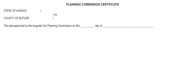
18.4. PLANNING COMMISSION CERTIFICATE. The certificate of the Planning Commission in the following form:

18.5. CITY ATTORNEY’S CERTIFICATE. If a plat is an addition to the City, a certificate signed by the City Attorney indicating that all conditions of K.S.A. 12-401 have been met.

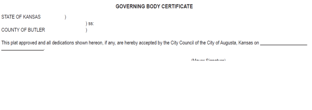
18.6. GOVERNING BODY CERTIFICATE. A certificate signed by the Governing Body approving the Final Plat and acceptance of dedications in the following form:

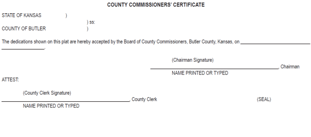
18.7. BOARD OF COUNTY COMMISSIONERS’ CERTIFICATE. A certificate signed by the Board of County Commissioners acceptance of dedications in the Planning Area in the following form:

18.8. TRANSFER RECORD. A place to note the transfer record date of the Butler County Clerk in the following form:

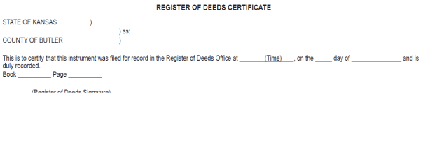
18.9. REGISTER OF DEEDS CERTIFICATE. The recording certificate of the Butler County Register of Deeds in the following form:

18.10. LAND SURVEYOR’S REVIEW. A certificate signed by a licensed Kansas land surveyor has reviewed the Final Plat. (K.S.A. 58-2005)

19. Planning Area Subdivision Waiver of Annexation. Subdivisions which lie in the “Planning Area” for which a request has been made for the extension of one or more City utility services shall agree to a waiver of protest of potential future annexation by a statement waiving the right to protest annexation, and such statement shall be included in the covenants of the subdivision which must be filed with the Butler County Register of Deeds. Such statement shall be located below the name of the subdivision.
19.1. “Owners of land within this subdivision do hereby bind themselves to waive any protest to annexation by the City of Augusta.”
20. MASTER DRAINAGE PLAN CERTIFICATION. A statement shall be included on the Final Plat to the effect that a Master Drainage Plan has been approved and made mandatory for all lots in the subdivision. The statement shall be located below the name of the subdivision. This certification is required only on plats within the City Limits.
21. The following information shall be submitted with the Final Plat:
21.1. A copy, if any, of restrictive covenants applicable to the subdivision. Such covenants shall be reviewed by the Planning Commission and City Staff to determine if any potential conflicts exist with the City’s statutes.
21.2. A title report by an abstract or a title insurance company, or an attorney’s opinion of title, showing the owner of the land and all other persons who have an interest therein, and describing any encumbrances on the plat, including such items as rights-of-way, easements, pipelines, leases, mortgages, real estate taxes, special assessments, and other encumbrances affecting the ownership.
21.3. A Final Master Drainage Plan. (See Section 505 and Section 506 for Final Master Drainage Plan requirements)
21.4. If determined necessary, a letter from the utility(ies) involved stating that satisfactory arrangements have been made by the Sub-divider guaranteeing the installation of their respective services.
21.5. Petitions and cost estimates for all proposed improvements within all phases of the subdivision.
21.6. A letter from the County Engineer which states that the guarantees for improvements, which may be required by these regulations for subdivisions or land outside of the City and not otherwise under the responsibility of City Officials, are satisfactory and in accordance with county standards.
21.7. Final Utility Plan.
The Master Drainage Plan shall be prepared by a licensed engineer that is familiar with the design of all streets, sewer and water installations within this jurisdiction. Storm water runoff from the site will exit the site in drainage easements or public right-of-way. The developer shall be responsible for obtaining all off-site drainage easements from the effected property owners. The engineer designated by the City shall review all proposed Master Drainage Plans. The developer shall pay the City for the engineering review based on the reviewing engineer’s fees.
In addition to the content requirements for the Preliminary Master Drainage Plan, the Master Drainage Plan shall also contain the following information:
1. All drainage easements shall be identified and dedicated on the final plat. Cross-lot drainage shall be discouraged without drainage easements. Cross-lot drainage may be accepted when it can be demonstrated that run-off from adjacent areas is insignificant or undue hardship is created by requiring a drainage easement.
2. Four-Corner Grading Plan.
2.1. Elevation of property corners.
2.2. Elevation and location of drainage swales and drainage appurtenances.
2.3. Street curb elevations at property lines, drainage structures and locations that could affect the drainage.
2.4. Benchmark information with one or more benchmarks with the subdivision.
2.5. Pad type and elevations. The Master Drainage Plan shall have the pad elevations for:
2.5.1. Garage floor;
2.5.2. Foundation wall/slab floor;
2.5.3. Basement window and/or lowest opening below foundation wall;
2.5.3.1. The recommended slope for drainage swales is 2%. The minimum slope for drainage swales shall be 1%. Flatter slopes will require paving of the swale or underground pipe with inlets to maintain positive drainage. The ground elevation 10 feet away from the house shall be a minimum of 6 inches (finished grade including sod, etc.) below the lowest house opening.
2.5.3.2. Each lot on the Master Drainage Plan shall stipulate the type of foundation that may be constructed on the lot with the following designations: (WO) walk-out basement; (B) Basement; and/or (VO) view-out basement, is allowed.
3. All calculations indicating storm sewer pipe sizes, pipe slopes, inlet sizes, street flow widths, storm water detention areas, static pool, 100-year flood elevations, and minimum pad elevations.
4. Utility Companies. The Administrator shall provide a copy of the Four-Corner Grading Plan and said utility companies shall comply with these regulations. City staff or an engineer appointed by the City shall coordinate the proper placement of all utilities within the utility/drainage easement. The design engineer shall hold a pre-construction meeting with all utility companies prior to the placement of streets and other utilities. The design engineer shall coordinate the installation of all underground utilities with the appropriate utility engineering staffs and contractors. All underground utilities shall be installed in the utility/drainage easement before the drainage way is constructed do r shall require the utility companies to put the grade back to the original level after construction. Utility and building contractors are required to protect and maintain rear flow line monuments during construction. Utility and building contractors who remove any lot monuments, front or back, shall be required to hire a licensed surveyor to replace the missing monument before the final occupancy inspection and provide documentation of same.
The Master Drainage Plan shall be prepared by a licensed engineer that is familiar with the design of all roads, sewer and water installations within Butler County. The design engineer will determine if water detention areas and downstream drainage easements are required. The developer shall be responsible for obtaining all off-site drainage easements from the effected property owners. The engineer designated by the City or the City staff may review all proposed Master Drainage Plan. The developer shall pay the City for the engineering review based on the reviewing engineer’s fees.
1. All drainage easements shall be identified and dedicated on the final plat. Cross-lot drainage shall be discouraged without drainage easements. Cross-lot drainage may be accepted when it can be demonstrated that run-off from adjacent areas is insignificant or undue hardship is created by requiring a drainage easement.
2. Four-Corner Grading Plan.
2.1. Elevation of property corners.
2.2. Elevation and location of drainage swales and drainage appurtenances.
2.3. Street curb elevations at property lines, drainage structures and locations that could affect the drainage.
2.4. Benchmark information with one or more benchmarks with the subdivision.
2.5. Pad type and elevations. The Master Drainage Plan shall have the pad elevations for:
2.5.1. Garage floor;
2.5.2. Foundation wall/slab floor;
2.5.3. Basement window and/or lowest opening below foundation wall;
2.5.3.1. The recommended slope for drainage swales is 2%. The minimum slope for drainage swales shall be 1%. Flatter slopes will require paving of the swale or underground pipe with inlets to maintain positive drainage. The ground elevation 10 feet away from the house shall be a minimum of 6 inches (finished grade including sod, etc.) below the lowest house opening.
2.5.3.2. Each lot on the Master Drainage Plan shall stipulate the type of foundation that may be constructed on the lot with the following designations: (WO) walk-out basement; (B) Basement; and/or (VO) view-out basement, is allowed.
3. All calculations indicating storm sewer pipe sizes, pipe slopes, inlet sizes, street flow widths, storm water detention areas, static pool, 100-year flood elevations, and minimum pad elevations.
4. Utility Companies. The Administrator shall provide a copy of the Four-Corner Grading Plan and said utility companies shall comply with these regulations. City staff or an engineer appointed by the City shall coordinate the proper placement of all utilities within the utility/drainage easement. The design engineer shall hold a pre-construction meeting with all utility companies prior to the placement of streets and other utilities. The design engineer shall coordinate the installation of all underground utilities with the appropriate utility engineering staffs and contractors. All underground utilities shall be installed in the utility/drainage easement before the drainage way is constructed do r shall require the utility companies to put the grade back to the original level after construction. Utility and building contractors are required to protect and maintain rear flow line monuments during construction. Utility and building contractors who remove any lot monuments, front or back, shall be required to hire a licensed surveyor to replace the missing monument before the final occupancy inspection and provide documentation of same.